Stats

🏁 130 km đŸ”ïž 2400m đŸ›« 1050mm ⭐⭐⭐
Download the route

The route

Part 1: The road to Casabermeja

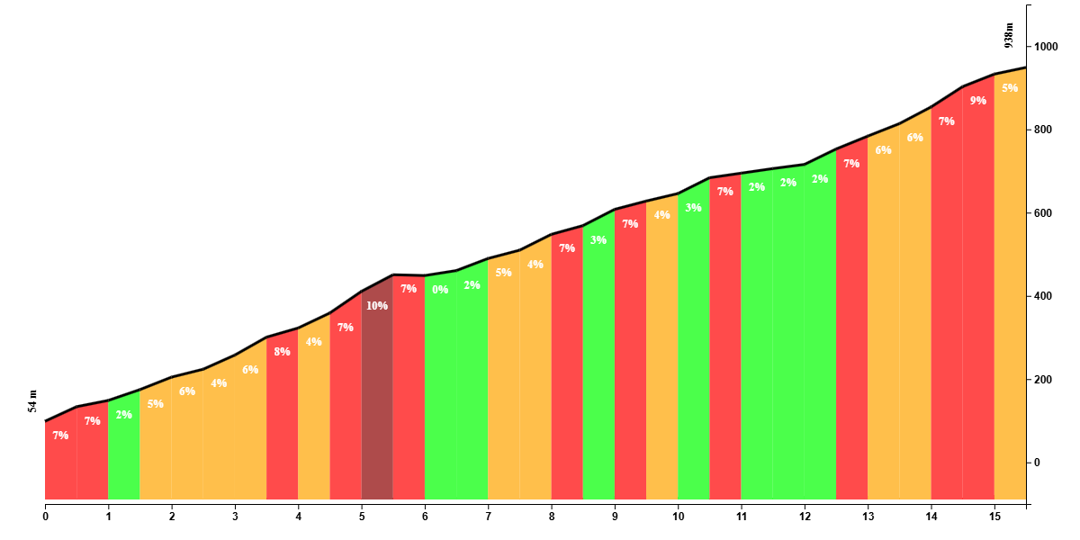
Unless you head out west, most of the routes that start in Málaga take you on roads that go uphill. This route does too and leads you out of the city via the botanical garden and along a less pitoresque road next to the highway. Once you’ve reached the top of this road, you leave the chaos behind and enter a different world. Passed the artificial lake and dam of Agujero, a long and undulating climb to Casabermeja awaits you.

This climb really consists of 4 uphill sections. If you count the part of getting to the lake as a hill, this climb is 28 km long in total with 5 uphill sections and 4 short descents. The first section after the lake is the perfect training climb. It’s a smooth ribbon of tarmac with many turns and it never gets really steep, even though there are short ramps that flirt with the 10% gradient. It’s also not too long before you reach Vendo Miel, which heralds the summit of this part of the climb. At Vendo Miel, you have a viewpoint of the Guadalhorce valley, and if you feel like stopping, you could take a selfie with one of the several cats that linger around.


A short descent is on the menu for the next few kilometers. It is not an overly technical descent but the road surface isn’t in the same shape as one can expect from the Spanish roads. A final dive should launch you to tackle the hardest part of this climb, and while it is merely 2 kilometers long, the going gets tough, and is excarcerbated by little protection from the sun and a relatively bad road surface. At least the gradients are constants and allow you to get into your rhythm. When you think you’ve reached the summit - and your Garmin computer will tell you that, you haven’t actually reached the top. You may be tempted to switch to the big ring, but the road quietly keeps on creeping up for a kilometer or 2. Only then is there a quick descent along a little settlement where you’ll most likely have to navigate through the goats and friendly dogs to start climbing again.


The third stage of the climb is also a short one that mercifully has a constant gradient of about 7%. If you can find a decent cadance, it’s a pleasant ride up. You’ll be rewarded with another short descent, and before you know it, you’re climbing again. This last part is nothing to fear as it never gets steep and it’s only an effort of a few minutes before you reach the summit at one of the oldest ventas (roadside restaurants) of Málaga, Ventorrillo Patascortas.

Part 2: crossing the A-356

28 km in, you can relax your legs a few minutes with the descent towards Casabermeja. The descent isn’t overly technical but it the road is narrow and there are a few blind corners that reveal upcoming traffic at the very last second. Once in the outskirts of Casababermeja, you can go for a coffee at the establishment at the roundabout or make a quick detour to the village. Otherwise, head straight down, cross the tunnel and be on your way to the A-356 towards the capital of the Montes de Málaga, Colmenar.


This stretch of 8 km isn’t the nicest road to be on, I’ll be honest. The road invites cars to speed and fatal accidents have happened on this road recently, although not with cyclists as far as I know. The road is undulating and mostly creeps up through the valley towards Axarquia. It’s only when you reverse the route that you appreciate the difficulty of this section as you can get to high speeds down here. Go right where the signs show Colmenar, after which the gradient kicks up to a maximum of 9% upon entering the outskirts of Colmenar.

Part 3: Montes de MĂĄlaga

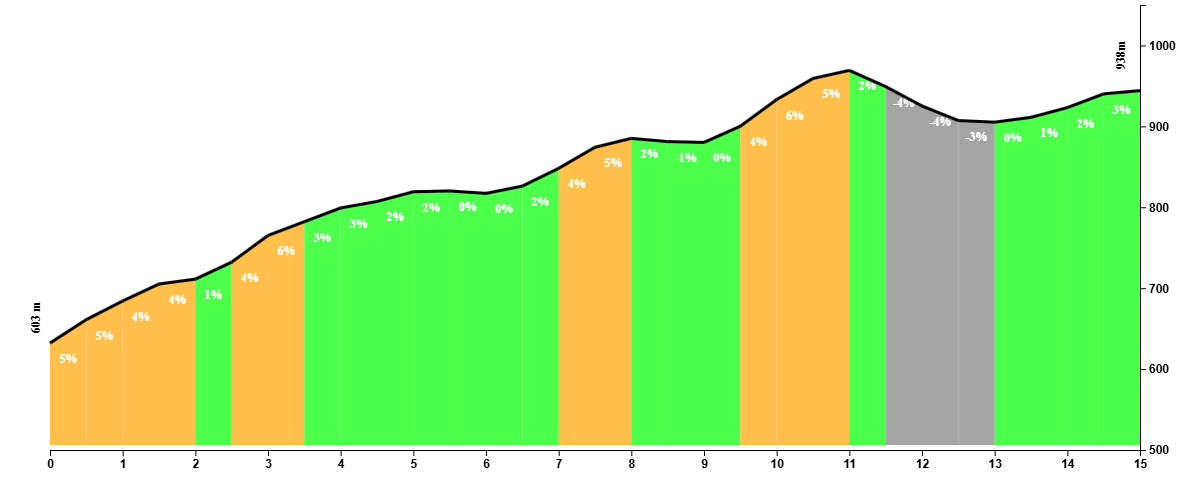
The famous Balcon de los Montes is a classic stop for cyclists and motorists and it marks the beginning of the Puerto del LeĂłn. The way up to the summit is about 13km away from here. If you were to start your ride from here, this side of the hill would be a perfect warmup climb, but after 40 kilometers of mostly uphill riding, this one may empty your tanks.


The butter-smooth ribbon of tarmac takes you through the beautiful Montes de Málaga which you should be able to enjoy most of the time since the climb isn’t overly difficulty. At least, when you’re not looking at your shifters to adjust to the constant changes in the gradient. Steeper sections of 10% are rewarded with Spanish flat sections and even the odd descent, before you have to do it all over again a few times over.


Halfway through this climb will you get a spectacular view of the impressive La Maroma and the villages of Periana, Alcaucín, and Canillas de Aceituno. Like the climb of the Puerto del León via the A-7000, the toughest section is at the end. It’s a punishing section where the gradient slowly goes up to 11%, and it requires an effort that makes your legs feel like lead for the last kilometer or so towards the highest point of the route at 950m.


A short descent takes you to Venta Galwey. If you go left, you go down to Málaga via Olías. If you go straight, you’ll go down the A-7000 that takes you straight to the city center. There’s one last kick of a few hundred meters where you’ll be relieved to see the sign that you’ve reached the Puerto del León. From here on, it’s 18 kilometers down. There are parts of the climb that softly go up, but you’ll have enough speed that you might not even notice it.


This descent is great for practicing your cornering skills, as there are a lot of corners. Although it’s a fast descent and it has many corners, it’s not an overly difficult descent. When traffic’s thin, it’s an extremely pleasant way down with awesome views over the city.

Alternative routes

Reverse

If you reverse the route, you’ll go up the Puerto del León and go downhill until you reach Casabermeja, and then you’ll need to do tackle three short climbs in the 28 km stretch towards Málaga. The route has a lots of corners and the descent will be quiet slow as a result of that.

Annex: OlĂ­as

For those wanting to add 15 kilometers to the route can turn left at Venta Galwey to go back to MĂĄlaga via OlĂ­as and El Palo. Mind you that this will also add 100m of extra elevation gain.

Fueling up

On the way to Casabermeja, there are several ‘ventas’ (roadside restaurants) where the locals go for long lunches during the weekends. Venta El TunĂ©l, aptly called because it’s right next to a tiny tunnel, is a very popular one. Further up the road, there’s also Venta Montevideo and at the final climb there’s one of the oldest ventas of the province, El Ventorillo Patascortas.


In the village of Casababermeja, you can stop at restaurant El Puerto which is on the route, or take a detour to the village. And if you’re in a hurry, you can buy provisions in the petrol station a bit further up.


In Colmenar, there’s the famous Balcon de los Montes which you’ll find on the right hand side upon arriving at the village. And at the summit of Puerto León, there’s always the Bar Fuente de la Reina.

Tips

Fill up your bottles for the first half of the ride. If you leave early on the morning, the ventas will likely be closed and you’ll have to wait until you reach Casabermeja to fill up.


You’ll be climbing a lot, so don’t go overboard on the first climbs that you may lull you in a false sense of confidence, assuming it’ll be this easy all the way. There are no monster climbs or really difficult sections on this route, but most of the route goes up and only the last 20 kilometers is where you really can actually relax your legs.